
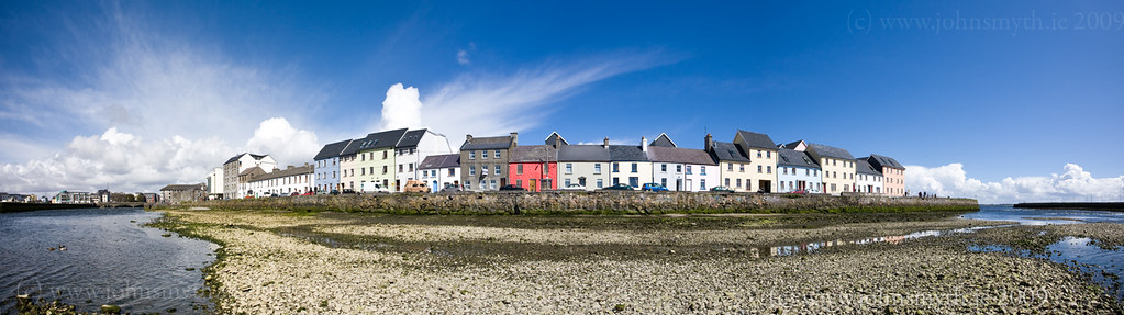
Where has all the water gone ? Low tide at the Long Walk – see bigger version here.
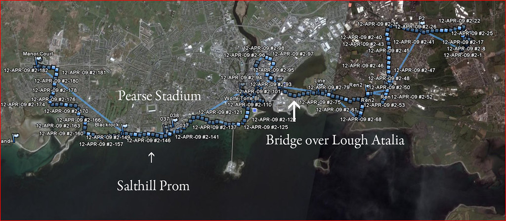
I was on vacation for Good Friday [April 10th] and I had just one chore to do – I had to get my car serviced. The garage was in the east of the city (in Doughiska, beside the NCT centre), and I live in Knocknacarra, to the west. How would I get back home ? Met Eireann had predicted poor weather so I didn’t plan anything for that day, but I decided that I would walk home from the garage. In the end, I walked 12.5 miles – I left the garage around 9am and got back to my house around 3pm [I could have done it a lot faster but I kept stopping for food. Did I mention that I love food?] Of course, I also brought a couple of cameras so I stopped for the odd picture or two (or two hundred).

Click here for a bigger version.
Luckily, the weather forecast didn’t live up to its billing either. Apart from a hail shower just after I started walking, the day was warm and sunny. The screenshot above is from Google Earth and shows my path home. I had set my GPS unit (it’s a Garmin eTrex) to constantly record my route home – each of the blue squares/dots shows when the GPS made an entry in the Trail file. The blue flags were places of interest that I marked along the way. I stayed along the coast most of the time – walking to Ballyloughaun beach in Renmore and then walking up to the Army Barracks to cross Lough Atalia by the path beside the rail bridge. Once I crossed the Corrib, I walked out by the Claddagh, along South Park and then on to Salthill Promenade and then up the hill to Knocknacarra and home. By the time I got home, my car was ready – this time, I took a lift back.
Walking along the Long Walk (yes – that is the Long Walk name-checked in Steve Earle’s song, Galway Girl), I noticed that the water recedes quite dramatically at low tide, so that the Corrib becomes just a narrow stream (behind me as I took the pictures). I decided to walk right out to the edge of the channel and made the panorama image at the top of this post. It is created by taking a series of images from the one spot (from left to right) and then joining them together in Photoshop. The image is also a distorted view – the Long Walk is a straight road – the distortion is caused by taking all of the pictures from the one spot, and with a very wide angle lens (17mm). The full image was about 1.5 Gb as a Photoshop file, and the printable version will print to 3 feet by 10 inches at 200 dpi (I haven’t made a print yet – I don’t have a wall big enough to hang it at home).
If you have a wall big enough, you can get a print here [you can also order smaller sizes].
Really lovely shot!